
Overnight flooding in the Highland Lakes area; ‘very strong’ El Niño on the horizon
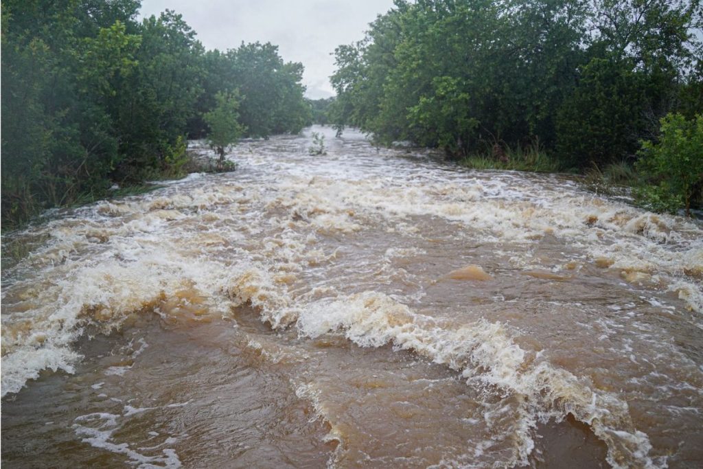
Water was rushing through Flatrock Creek in south Marble Falls on the morning of Monday, June 15. While the low water crossing over the creek on FM 2147 was passable by 9 a.m. on Monday, it was closed to through traffic just a few hours earlier. Staff photo by Dakota Morrissiey
Low water crossings, creeks, and some roadways in the Highland Lakes area were flooded on the night of Sunday, June 14, due to heavy rainfall across Burnet and Llano counties. More precipitation is expected Monday night, Tuesday, and later in the week. Even more wet weather could be in store in the coming months, with climate scientists predicting a “very strong” El Niño.
Much of Central Texas was under a flood watch on Sunday, with several inches of rain falling throughout Burnet, Llano, and Travis counties, which led to rising waterways that were impassable until Monday morning in some cases.
A 5 a.m. statement issued by the Marble Falls Area Volunteer Fire Department on Monday, June 15, read:
“There are several low water crossings in our area that are currently flooded, especially on the county roads. There are also closures in the city of Marble Falls and Horseshoe Bay.”
At the time, the FM 2147 low water crossing on Flatrock Creek was closed, the CR 120 crossings over Backbone Creek were closed, the crossings on CR 401 and CR 404 over Double Horn Creek were closed, the crossing on CR 404 near Krause Springs in Spicewood was closed, and there were reports that water was over the road on CR 120 near RR 1431 West.
According to Marble Falls Area VFD Chief Derrick Curtis, residents should be vigilant about potential flooding in the coming days.
“The (Highland Lakes area) has been saturated for a few weeks now, so all of the low water crossings could flood (with more rain),” he said.
Burnet and Llano counties were under a National Weather Service flood watch on Monday morning that originally extended until 7 p.m. on Tuesday, but that watch was no longer in effect at the time of this article’s publication on Monday afternoon.
Rain
The primary cause of Sunday night’s flooding was several inches of rainfall that fell in just a few hours. The rain was primarily concentrated in southern Burnet and Llano counties.
The following numbers are rainfall totals measured by Lower Colorado River Authority rain gauges in the Highland Lakes between 2:10 p.m. on Sunday and 2:10 p.m. on Monday:
- Honey Creek near Kingsland- 4.11 inches
- Marble Falls 8 SSW- 3.92 inches
- Kingsland 9 WSW- 3.69 inches
- Lake LBJ at RM 2900 bridge- 3.15 inches
- Round Mountain 6 WNW- 3.14 inches
The LCRA did not open any floodgates in the Highland Lakes area during the recent flooding, but the authority did release storm runoff through hydroelectric generation on multiple lakes.
Farther downstream, a gate on Tom Miller Dam was temporarily opened, and a floodgate on Lake Bastrop Dam was still partially open as of 2:15 p.m. on Monday.
El Niño
The National Oceanic and Atmospheric Administration announced on June 11 that El Niño conditions had formed and that they would likely intensify in the winter of 2026-27.
While the climate pattern has sweeping impacts across the globe, for Central Texas, El Niño typically means warmer, wetter weather, especially in the winter.
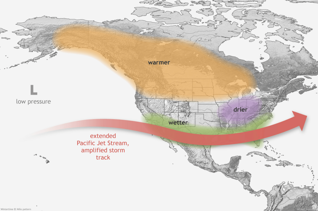
El Niño is a phase of the El Niño Southern Oscillation (ENSO) climate pattern, which is dictated by the surface temperature of the equatorial region of the Pacific Ocean. El Niño occurs when temperatures are 0.5°C above average for several consecutive months. La Niña, the counterpart to El Niño, occurs when the temperature is 0.5°C below average for several consecutive months. For Central Texas, La Niña usually means drier weather.
“El Niño, the warm phase of the (ENSO), is predicted to intensify to a moderate or strong level this fall,” reads a media release issued by NOAA on June 11. “Forecasters predict a 63 percent chance of sea surface temperatures exceeding 2.0°C in the Nino-monitored region of the Pacific. If this threshold is surpassed, NOAA considers the event a ‘very strong’ El Niño.”
The climate patterns are not guarantees of changes in weather, but in recent history, Central Texas saw the full impacts of a three-year La Niña and accompanying drought conditions that lasted 2021-23. The historic flooding of the Llano and Colorado rivers in October 2018 occurred during a particularly intense El Niño that lasted from 2018-19.